It’s raining quite hard. We rode 100 miles yesterday with a tailwind, happy to be back on pavement. We just learned that we’ve already covered more miles than this year’s Tour de France (2,173 miles), so we feel okay spending a day warm and dry in a cabin. Today we only rode 1/2 mile from the Moose Creek territorial campground to the Moose Creek Lodge.
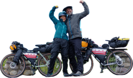
We’re back in Dawson City after our fantastic 1,150 mile, 22-day round-trip up to the Arctic Ocean. We didn’t run into any other bicyclists planning to ride both ways. The general consensus seems to be that we’re odd ducks. But we’re happy being odd ducks and we had a lot of fun out there on the Dempster. We’d be hard pressed to find somewhere more remote to spend that much time. We loved it. What a beautiful ride!
We’ve already posted about most of the route. So what’s new in the past few days?
We successfully navigated a very complicated detour the Yukon government set up to get around a sinkhole on the shoulder:
We never would’ve figured it out without the detour sign!
We passed the 2,000 mile mark for our trip!
We also had our first direct interaction with a grizzly bear. An oncoming RV flagged us down to let us know that they had just passed a grizzly 200 meters down the road, then they wished us luck and drove away. We cautiously continued riding and almost immediately we could see a grizzly ambling in the distance:
None shall pass! (At least on bicycles)
Once we snapped a pic, we put the phone away and made sure the bear was aware of us so it wouldn’t get startled and charge. Giselle unleashed a few quick blasts from her air horn and the bear seemed intrigued. Not the reaction we had hoped for. We turned our bikes sideways in front of us and raised our arms in the air to make ourselves look bigger. The grizzly was still curious and kept walking towards us. We were concerned and thought we might need to use our bear spray if the bear got much closer (or worse, if it charged us) but then Bill switched from his “hey bear, we’re friendly and non-threatening” voice to his stern “get out of here bear, go into the woods!” voice. The bear seemed to understand and dejectedly loped to where Bill was emphatically pointing — off the road. We could hear the bear cracking through the brush so we knew it was a bit off the road, but we still kept our eyes and ears open as we cautiously rode past. The best possible outcome for everyone involved.
The weather finally got kinda cold! After roasting north of the arctic circle, it was about 40 degrees Monday night in Tombstone Mountain campground, our last night on the Dempster. Giselle finally was able to wear her down booties and use her extra-cozy sleeping bag liner!
As we get further south, it’s getting kinda dark-ish at night. Still don’t quite need a headlamp yet.
Updated Totals:
2,142 miles pedaled
94,766 feet climbed
Today: rest day in Dawson City before we start riding toward Whitehorse. All the roads should be paved from here on out so we’re hopefully done with mud-caked bikes. We’re going to miss the days of endless gravel.
We were both excited to get back on the Dempster after our foray up the ITH. We’ve had four fantastic days of riding to get to Eagle Plains. But after eight straight days in the saddle it’s time for a REST DAY!!!
A few details from recent days:
We continue to find fantastic campsites when we need them!
Perfect spot just north of Midway Lake
Midway Lake is an interesting temporary town where locals build camps that they mostly use for one long weekend in August for a music festival.
Midway Lake is on the left
Several people have asked how bear storage is different than our last trip. There aren’t tall enough trees up here to do a regular bear hang so we brought Ursaks, bear resistant bags that you secure to something sturdy. We put our food in scent-proof bags and hope for the best. It’s working so far!
Ursaks in action! The bells will hopefully alert us if someone finds our food
We crossed back into the Yukon!
Brand new sign!
Drone video of the ride up to the Yukon border
We also crossed back below the Arctic Circle. Didn’t feel like returning to the non-Arctic latitudes merited a celebratory video. (Sorry!)
The long climb back to Eagle Plains starts at the metal grate bridge over the Eagle River.
This silly-looking sign does a shockingly good job of describing the experience, while also looking like an awesome disco album cover:
Across the valley, you can hopefully see the diagonal line of the road up to Eagle Plains and the dust plumes from trucks
Updated Totals:
1,885 miles pedaled
85,500 feet climbed
Donuts consumed: 6 (we bought our first donuts of the trip in Fort McPherson!)
After our prior blog post from Tuk, Bill took the final video in our riveting series called “is the sun gonna set?”
Spoiler: not really
The next morning we started back to Inuvik. We made it about halfway and stayed at a fantastic little campsite nestled near one of the few bridges over running fresh water.
It was a scramble to get down here from the road but it was worth it!
Then Bill finally stopped bellyaching about the horrific deep gravel and made peace with the idea that we would eventually persevere, and took some drone footage from this scenic and not all that heinous stretch of the road.
Hopefully this is how we’ll remember the Inuvik-to-Tuktoyaktuk Highway
We rode our bikes to the Arctic Friggin’ Ocean! It took a lot more effort to get to Tuktoyaktuk than expected, but we’re here!
One of us is better at showing enthusiasm
Some people ride the 95 miles from Inuvik to Tuk in one day. We couldn’t make it, but we attribute it not to a lack of toughness, but instead fervently believe that it was extra windy yesterday and the gravel was deeper than normal. Still, we made it 75 miles. Then we were tired.
The landscape became filled with ponds and lakes
The Inuvik to Tuk Highway has almost no pullouts or camping spots but we stumbled upon a gravel lot where locals park snowmobiles in preparation for winter. It was perfect timing too because we were really tired and needed to stop. We weren’t really sure about putting our tent on the delicate tundra, both because we didn’t want to hurt the plants and we didn’t want to wake up in a swampy bog.
Midnight Sun (technically 1am Sun) over our impromptu campsite
We also started seeing pingos! These cool landforms are made when liquid water gets trapped under the permafrost, then expands as it freezes. (This explanation is over-simplified, Parks Canada has more info). The pingos up here are quite enormous!
Our first pingo sighting!Slightly closer. Ibyuk Pingo is 16 stories tall!!
Tonight we’re camping about 10 feet from the ocean!
That’s it for now, it’s time for us to nijiihaih:
Stop signs in Inuvik also are in Gwich’in and Inuvialuktun
We made it to Inuvik! This is the end of the Dempster Highway! We are going to continue a bit further north to the Arctic Ocean at Tuktoyaktuk. But first we’re going to take a rest day here in Inuvik. It’s by far the biggest metropolis we’ve seen in quite a while. It’s even got at least one traffic signal! More importantly we’re sleeping in a nice hotel, have showered, done laundry, and had a fantastic dinner! And dessert! Then we stopped for snacks at the grocery store!
The terrain has changed markedly over the past few days. First, we left the mountain ridges behind for small hills dotted by lakes and ponds. Now we’re in an almost completely flat landscape. We’ve also entered the land of mosquitoes and biting flies. This is what we signed up for.
It’s also been very hot the past few days, above 80 degrees. This isn’t exactly what we thought it would be like north of the Arctic Circle! Not much use for all these warm layers we’re lugging around yet.
People are continuing to surprise us with little acts of kindness. We’ve taken a few more ferries. We also got a ride across a river with a friendly man in a motorboat who offered to get us across faster rather than waiting for the ferry to come back. People have offered us water, showers, and lots of encouragement.
It’s also still very bright at night! We both woke up last night at 10:45pm, looked at Bill’s watch and were so disoriented because it was so bright outside the tent. We both thought we had somehow slept through the night and it was already 10:45 AM! Bill woke up again at midnight and tried to take a follow-up video showing that the sun doesn’t actually set now that we’re so far north, but it was pretty cloudy:
You can kinda tell the sun is still pretty high in the sky behind the clouds.
Today is July 16th. The sun won’t set in Inuvik until July 19th. And even then, it won’t get anywhere close to dark, just kind of a bright dusk. We’ll see if we can get a better video.
We also took drone footage of a great informal campsite we happily stumbled upon a few nights ago, and also footage showing the vastly different landscape we entered as we moved north — flat as a pancake and the road is as straight as can be!
Updated stats:
1,460 miles pedaled
66,200 feet climbed
Days Bill has worn padded shorts: zero
Tomorrow: rest day in Inuvik, our dot won’t move
Link to our tracker map (you can click “view all” to see our entire trip, and click the “i” to change map types)
We made it to the Arctic Circle! We’ll never get tired of being able to say we got somewhere on our bicycles, but being able to say “we got to the Arctic Circle on our bicycles” is pretty darn cool. And humbling.
We also got to ride on our first (and second!) active runways, because several stretches of the Dempster Highway double as runways. No landings while we were there though.
We crossed into a new province: the Northwest Territories! This brings even more complications because our time zone changed yet again. Doesn’t really change our day much though. Late to rise, early to bed.
Welcome to NWT
We saw our first grizzlies! As we crossed into the Northwest Territories, we saw 6 brown bears, including two adorable cubs, all from a safe distance.
Blurry photo of mama bear and two cubs. Bigfoot and the Loch Ness Monster too.
Oh yeah, and in the middle of all this, GISELLE HAD A BIRTHDAY!!! Thanks to everyone for the great wishes! We celebrated on the road and had a great day of riding.
We are about halfway up the Dempster Highway on our jaunt up to the Arctic Ocean.
We started in the striking Tombstone Mountains. Lots of climbing among jagged peaks hidden by clouds. (not a lot of pics on our phones, but there’s drone video below and DSLR photos will be available a long time from now when we’re home)
The Dempster is VERY remote. It’s a pretty rugged gravel road and the surface seems to change all the time. Just when we get used to a smooth rolling section, it switches to washboard or deep gravel. But it’s all been rideable and we’re loving (almost) every minute.
A few adventures of note: we camped near Engineer Creek. We knew the water was undrinkable due to iron leaching from permafrost (thanks global warming!). But we weren’t sure how to know when the water would be undrinkable. We shouldn’t have worried.
Engineer Creek. Yum.
What was fascinating was when Bill went down to the Ogilvie River to filter water, he could see where it mixed with Engineer Creek.
Bill chose to filter upriver before the river joined the creek
Also at Engineer Creek Campground a trail angel went exceptionally above and beyond and brought us a bunch of treats including a fantastic feast for Giselle.
Steak, shrimp, baked potatoes, broccoli casserole, and so much more!!
Drivers have been so generous and helpful, offering sodas and water as we slogged up hills. We must be quite a spectacle!
Now we’re camping at Eagle Plains. We had a box sent ahead and it arrived safely. Now we’re having a great dinner!
And of course, we took drone footage when we had battery power, when it wasn’t raining, when it wasn’t too windy.
We made it to Canada! The last few days were filled to the brim with type-2 fun. Getting to the border was a “mile high” day because we had to climb over 5,280 feet in cumulative elevation to reach the land of the metric system.
We never did figure out why the chicken crossed the road, but we did eat lunch in Chicken twice.
The Taylor Highway on the US side was very hilly.
We camped at this fantastic cyclists-only site a few nights ago!
Just before the border we turned onto the Top of the World Highway, which true to its name runs along exposed ridgelines and was very windy. It also started raining. We decided to stop a bit before our planned destination for the night and threw our tent down in a little gravel pullout on the side of the road. We made dinner in a drizzle, then hopped in the tent hoping it would be less rainy when we awoke from hibernation 10 hours later.
It didn’t stop raining. We woke up, and since everything was soaked by the pouring rain, we skipped hot coffee and breakfast. We scarfed down some pulverized pop-tarts we had been schlepping for a while and started riding. Dawson City was only 50km away (about 30 miles to un-civilized Americans) and it looked mostly downhill.
Unfortunately, the dirt road was now very muddy and we got totally soaked even in our full rain gear. The rolling hills that would have been a delight on a sunny day were now a total slog. Our brakes became much less effective the more mud they collected, which turned the long downhill into Dawson City a white-knuckled adventure. Even though the temperature rose from the low-40s to the low-50s as we got to lower elevation, our shoes were filled with water and we were quite chilled while we waited for the ferry to cross the Yukon River.
Warming up on the ferry
In northern Canada, many of the rivers don’t have bridges, even on major arteries, they have free ferries to shuttle all the traffic across. The Yukon is an incredibly swift river. Most people need to stay in their cars but cyclists get to sit on a cold metal bench on the side. But luckily that red square next to Giselle’s head in the photo above is a hatch to the engine, so delightfully hot diesel air blasted from that vent and warmed us up. Normally we would’ve hated sitting there but yesterday the hot fumes were a godsend because it stopped the involuntary shivering.
As we slogged into town caked in mud in the early afternoon, people kept stopping us to say they had passed us on the road and to congratulate us on having made it. The recognition felt good but we were cold and wet and just wanted to find shelter for the night and, most importantly, find our first cup of coffee and some real food.
But now we’re settled and taking a rest day in Dawson City!
The Wolf’s Den cabin
We spread out all our stuff on our cabin’s porch so it looked like a yard sale of gross things nobody would ever want, but it all gradually dried. Now we look somewhat civilized. After a delicious fish-n-chips dinner we had ice cream and Giselle’s “two-scoop” cone was about as big as her head. The sun is out, we’re incredibly well-fed, all our clothes are freshly laundered, and all our gear is dry! So it turned out to be a pretty good day after all.
Today: bike maintenance and logistics for our ride up the Dempster Highway to the Arctic Ocean! There is an informal system where RV’ers carry cyclists’ food several hundred miles up the road to Eagle Plains since there’s a bit of a food desert without stores in the middle of the route. RVs and motorcycles can just power on to the next town but most cyclists can’t cover the distance quickly enough. We need to go to the various stores in town and get whatever we can find to cram in a box to send to ourselves. Also we’ll probably eat a few times today.
We sleep so well when we’re bikepacking, we’re rarely awake after dark. And in this part of the world it rarely gets dark at all.
But Bill sleepily made this video for you to try to answer all your questions. It was pretty cloudy when he made this video, and it’s pretty cloudy today. Honestly it is about as bright at noon as it was last night at midnight!
Our highest production values yet!
We’ll cross into Canada tomorrow and our days of frequent cell/wifi connection may be coming to an end.