The Denali Highway!!

We rode the Denali Highway on June 24th through 26th. Almost everyone we met (all drivers or motorcyclists) thought we were crazy for attempting to cross what they described as a grueling journey across a miserably potholed road. Before we give our verdict on the route, here’s an update on some of the “firsts” we encountered over the past few days: we rode through our first torrential rain and got totally soaked, we rode through our first (small) hailstorm, we had to skip our first dinner due to it being too rainy to go outside to cook, and we encountered our first swarms of mutated super-mosquitoes.

So, taking all that into account, what did we think of the Denali Highway? We absolutely loved it!!!

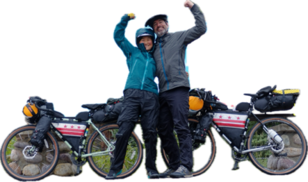
This was probably the best three days of riding you can have on a bicycle. We got wet, we got dry. We got tired, we got rejuvenated. We got surrounded by mosquitoes, we just… grumbled and did the best we could.

After every tough climb we were rewarded with views like these:

Trumpeter swans in paradise
It’s worth climbing in the rain to get this view as the clouds part

It was great to see other cyclists on the Denali Highway, some independent bikepackers like us, some on organized tours, and most impressively a huge group of kids from some kind of awesome adventure summer camp!

We were also surprised by how many hot meals we were able to get from remote lodges along the way. Giselle had more hamburgers than she’s probably had in any 3-day period in decades. Bill had… a lot of grilled cheese or whatever non-cheeseburger option was available.

Once we got onto the Richardson Highway, we raced a thunderstorm to Meier’s Lake Roadhouse, where we were utterly surprised to be offered a free night in a cabin that the owner makes available for cyclists!

Meier’s Lake Roadhouse
View from our little cabin!

And most importantly, here’s a new drone video for you of our ride across the Denali Highway!

Another rough cut straight from the drone’s eyes to you!

Current cumulative stats:

637 miles

27,731 feet climbed

Zero despairing cries of sadness

Tomorrow will be a rest day, then we’ll head north to Tok!

Denali National Park!

We spent a great three days cycling in Denali National Park. Like so much of what we’ve seen so far, it’s hard to convey the awesome scale of everything and the jaw-dropping beauty around every corner.

We had really hoped to cycle to the end of the Denali Park Road by hoofing around the landslide closures, but that is not currently possible — so we only went in about 40 miles. It was still such a great ride!

We stopped to let this ptarmigan family cross the road
Couldn’t see Denali (the mtn) inside the park but we had already seen it from the southeast
Our cozy campsite at Igloo Creek out in the middle of the park

Back near the park entrance we stayed at Riley Creek. They have fantastic walk-in sites with ample food storage to keep us bear safe.

View from the bench behind our campsite at Riley Creek!

Tomorrow we’ll set off down the Denali Highway, which cuts east along the Alaska Range between Cantwell and Paxson. Despite being called a “highway,” it is a very remote gravel road and we should get some more drone video for you once we reappear with signal in about a week. (Drones are prohibited on NPS land, which we are definitely ok with and gladly complied)

Distance traveled: 402 mi

Elevation gained: 17,123 ft

Rest Day in Cantwell, AK

We’re taking a day off in Cantwell, so our dot didn’t move today. We had our first showers and did our first laundry of the ride. Yay! Unfortunately, neither of the town’s restaurants were open so we did our best at the gas station. Bikepacking can be pretty glamorous sometimes. Just not today.

The last few days have been straightforward: ride north on the Parks Highway. To date we’ve ridden 275 miles and climbed 10,000 feet in total elevation gain. We’ve only had 4 snickers bars so far (gasp!) but that number will go up once our big bag of trail mix is gone.

The closer you get to Denali, the less prominent it seems to be!

We kept pace with bald eagles a few times. No moose or bear sightings so far, and we’re ok with that.

Tomorrow we’re going to head up to Denali National Park. We may be a while without cell signal, although we’ve been surprised so far so who knows?

We’re doing our best to send cool air down to those of you roasting in a heat dome.

Recap: the trip so far

It’s only been a few days but we’re having a FANTASTIC trip. The weather has been phenomenal and the views are majestical.

Thursday night we finalized our packing. This is both a huge amount of stuff and an absolutely minimal amount of stuff considering we’re going to be out for months!

Organized chaos. Three boxes to check, two small boxes to carry on, and two little backpacks.

At 4am Friday morning we set off for Dulles in our monster-SUV.

Wide awake. And we definitely needed a big vehicle. Joia took one for the team by getting up to document (and probably make sure we didn’t miss our flight!)

Bill dozed on the flights, Giselle binged a ton of movies. When we got to Anchorage mid-afternoon we were utterly gobsmacked by the views from the terminal.

Our hotel shuttle worked perfectly, and then we got organized and slept for about 10 hours (still waking up about 6am local time).

First test ride was a success!

Anchorage has so many beautiful bike paths winding through the city, we didn’t have any trouble getting out of town.

So many of the highways have separated bike roads and even when we ride on the road the shoulders are wide and well-maintained.

Also, if you’re not afraid of avalanches you can totally pan for gold.

The ride up Hatcher Pass was a ton of work. A slow slog. But we made it, partly due to the encouragement of a friendly Alaska State Park Ranger we kept bumping into.

High-point of Hatcher Pass

Our photo drone named GlaDOS did a great job with our first video (which we sent out earlier), and we’re slowly getting to know her foibles. At one point she was “tracking” a pebble instead of Giselle and just hovered in mid-air which raised someone’s frustration. It was all worked out and we’ll find new problems next time. But hopefully have more great videos too.

GlaDOS frozen in mid-air watching the ground instead of tracking bike riders
Worth pushing our bikes for a bit!!!! GlaDOS snapped this photo and we aren’t sure how or why but we loved it.
Denali is pretty huge!

We’re spending the night in Talkeetna and have lucked out with fabulous views. More pics from our big camera eventually. But not today.

Time to follow our blue dot!

We are setting off from Anchorage! Over the next few days we will ride north over Hatcher Pass and then west to the Parks Highway.

Our flights yesterday were very smooth and the views were spectacular!!

Whoa

We zonked out pretty early after getting to our hotel but woke up to see the sun “set” just before midnight. The sky got a beautiful pink color but then it never really got dark. We knew that was going to happen but it still was impressive.

Our trusty Garmin InReach

This is the little gizmo allowing you to keep tabs on our trip, but it also lets us get weather forecasts, and lets us keep in touch with the outside world. Hopefully we don’t need to send an SOS but it’s always great to hear from you when we’re far afield!

To track us, go to http://share.garmin.com/gisellebill

You should be able to see our progress, including time and speed at each datapoint. We have it set up to record once every 20 minutes so try not to panic if our line doesn’t perfectly follow the roads on the map! (You can see more detail on a computer than a phone but either will work)

Also try to remember that Alaskan Daylight Time is 4 hours behind the east coast so it may seem like we’re riding late into the night (or getting up really late in the morning!).

More pics forthcoming. We’re just getting started!!

Planning for mosquitos

We’re only two days away from our trip! Everyone keeps asking about precautions for the Alaskan wildlife. Yes, we’ll carry bear spray and we’ll fastidiously keep our food in bear proof containers. But our biggest concern: epic swarms of mosquitos!

We’ve got head nets (which we hope not to need very often!), we’ve got a thermacell device that should create a magical wall of safety around our campsite.

You can tell the thermacell is gonna work because blue arrows and honeycomb patterns don’t lie!

We’ll also have bug spray. But hopefully the most effective thing we’ve done is sent our clothing to Insect Shield for them to treat our clothes with permethrin in the same process they use in clothing you can buy at outdoor stores.

You can tell they really did it because they imprinted all their info on each item. Well, we certainly HOPE they did it!

And they added new tags in the garments, right next to the annoying tags I had already cut out. oh well.

Hopefully the mosquitos won’t bother trying to bother us too much. We’ll soon find out!

Drone Test Flight

Full success! Can’t wait until we’ve got slightly more exciting footage to share!!

Camera drone test footage

The drone will be able to track us while we ride, for at least a few minutes at a time. We’ll try our best to make little videos like this using our phones but higher production values might need to wait until the fall when we’re at computers. Next drone videos will probably be from Alaska!

Test Ride to Alaska*

*A map of Alaska in Anacostia Park. We haven’t flown across the country yet! But it was a nice way to spend Sunday.

The map of Alaska needs a new coat of paint!

The faded Alaska map doesn’t make for as exciting of a photo as we had hoped. Still, it was a good test of our new bag setup that allows us to carry lots of food. This setup should also allow us to pack/unpack much faster and carry bulky items like fuel canisters or extra jars of peanut butter.

Another look of our 4-pannier setup while we stopped for obligatory ice cream

Riding to the Arctic Ocean!

It’s been five years since our last epic bicycle trip. Just when we thought we were back into our normal routine in early 2020, everyone’s world got upended. Luckily for us, the Great Divide was excellent preparation for being cooped up in small living quarters with limited access to food and supplies.

But it’s time for a new adventure.

In a few weeks, we’re going to fly to Anchorage, reassemble our bikes, and start riding. A massive landslide closed much of the road through Denali National Park, but we will be able to bypass the blockage on our bikes and have the western side of the park (mostly) to ourselves. Then we’ll resupply in Fairbanks, spend a day in a hot spring, then ride east into Canada and the Yukon before crossing the Arctic Circle in the Northwest Territories. Tuktoyaktuk is the northernmost road-accessible settlement in Canada. Our current plan is to ride south to Skagway, catch a ferry to Juneau, and fly home. But we might turn it into a loop and go back to Anchorage.

Bikepacking isn’t for everyone and we are incredibly lucky that our interests align, our skillsets are complementary, and we’re both amenable to the compromises in creature comforts this type of trip requires. We are beyond excited and can’t wait to share our trip with you.